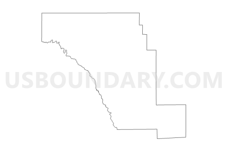
Middle Rio Grande Development Council PUMA, Texas
About
Outline

Summary
| Unique Area Identifier | 194159 |
| Name | Middle Rio Grande Development Council PUMA |
| State | Texas |
| Area (square miles) | 14,398.65 |
| Land Area (square miles) | 14,266.04 |
| Water Area (square miles) | 132.61 |
| % of Land Area | 99.08 |
| % of Water Area | 0.92 |
| Latitude of the Internal Point | 29.30323230 |
| Longtitude of the Internal Point | -100.19853410 |
Maps
Graphs
Select a template below for downloading or customizing gragh for Middle Rio Grande Development Council PUMA, Texas


Neighbors
Neighoring Public Use Microdata Area (by Name) Neighboring Public Use Microdata Area on the Map
- Alamo Area COG (Northwest) & Blanco County PUMA, TX
- Alamo Area COG (Southwest) PUMA, TX
- Concho Valley COG & Permian Basin Regional Planning Commission (East) PUMA, TX
- Rio Grande COG & Permian Basin Regional Planning Commission (West) PUMA, TX
- South Texas Development Council (South) & Coastal Bend COG (West) PUMA, TX
- South Texas Development Council--Webb County (North & East)--Laredo City (Outer) PUMA, TX
Top 10 Neighboring County (by Population) Neighboring County on the Map
- Webb County, TX (250,304)
- Maverick County, TX (54,258)
- Kerr County, TX (49,625)
- Val Verde County, TX (48,879)
- Medina County, TX (46,006)
- Atascosa County, TX (44,911)
- Uvalde County, TX (26,405)
- Bandera County, TX (20,485)
- Frio County, TX (17,217)
- Duval County, TX (11,782)
Top 10 Neighboring County Subdivision (by Population) Neighboring County Subdivision on the Map
- Eagle Pass CCD, Maverick County, TX (52,141)
- Del Rio CCD, Val Verde County, TX (48,030)
- Laredo North-Webb CCD, Webb County, TX (30,265)
- Uvalde CCD, Uvalde County, TX (23,148)
- Ingram CCD, Kerr County, TX (11,698)
- Pearsall CCD, Frio County, TX (11,171)
- Crystal City CCD, Zavala County, TX (8,565)
- Carrizo Springs CCD, Dimmit County, TX (7,715)
- Cotulla CCD, La Salle County, TX (5,124)
- Dilley CCD, Frio County, TX (4,674)
Top 10 Neighboring Place (by Population) Neighboring Place on the Map
- Del Rio city, TX (35,591)
- Eagle Pass city, TX (26,248)
- Uvalde city, TX (15,751)
- Eidson Road CDP, TX (8,960)
- Crystal City city, TX (7,138)
- Carrizo Springs city, TX (5,368)
- Chula Vista CDP, TX (3,818)
- Cotulla city, TX (3,603)
- Cienegas Terrace CDP, TX (3,424)
- Las Quintas Fronterizas CDP, TX (3,290)
Top 10 Neighboring Unified School District (by Population) Neighboring Unified School District on the Map
- United Independent School District, TX (156,720)
- Eagle Pass Independent School District, TX (54,258)
- San Felipe-Del Rio Consolidated Independent School District, TX (48,272)
- Uvalde Consolidated Independent School District, TX (22,959)
- Pearsall Independent School District, TX (11,900)
- Carrizo Springs Consolidated Independent School District, TX (9,996)
- Crystal City Independent School District, TX (8,573)
- Cotulla Independent School District, TX (6,790)
- Dilley Independent School District, TX (4,774)
- Junction Independent School District, TX (4,279)
Top 10 Neighboring State Legislative District Lower Chamber (by Population) Neighboring State Legislative District Lower Chamber on the Map
- State House District 73, TX (187,204)
- State House District 31, TX (165,121)
- State House District 35, TX (151,882)
- State House District 80, TX (149,638)
- State House District 53, TX (145,845)
- State House District 74, TX (143,566)
Top 10 Neighboring State Legislative District Upper Chamber (by Population) Neighboring State Legislative District Upper Chamber on the Map
- State Senate District 24, TX (778,148)
- State Senate District 19, TX (766,044)
- State Senate District 21, TX (752,602)
Top 10 Neighboring 111th Congressional District (by Population) Neighboring 111th Congressional District on the Map
- Congressional District 21, TX (856,954)
- Congressional District 28, TX (851,824)
- Congressional District 23, TX (847,651)
- Congressional District 15, TX (787,124)
- Congressional District 11, TX (710,682)
Top 10 Neighboring Census Tract (by Population) Neighboring Census Tract on the Map
- Census Tract 9507, Maverick County, TX (9,412)
- Census Tract 9502.01, Val Verde County, TX (8,827)
- Census Tract 9502.05, Maverick County, TX (8,704)
- Census Tract 9603.02, Kerr County, TX (7,942)
- Census Tract 9502, Uvalde County, TX (7,740)
- Census Tract 9502, Dimmit County, TX (7,715)
- Census Tract 9505, Val Verde County, TX (7,472)
- Census Tract 9503, Maverick County, TX (7,457)
- Census Tract 9502.01, Maverick County, TX (7,083)
- Census Tract 9503, La Salle County, TX (6,886)
Top 10 Neighboring 5-Digit ZIP Code Tabulation Area (by Population) Neighboring 5-Digit ZIP Code Tabulation Area on the Map
- 78045, TX (54,713)
- 78852, TX (53,040)
- 78840, TX (48,149)
- 78801, TX (21,780)
- 78061, TX (11,031)
- 78839, TX (8,578)
- 78834, TX (7,829)
- 78014, TX (4,987)
- 78017, TX (4,787)
- 76950, TX (4,180)


